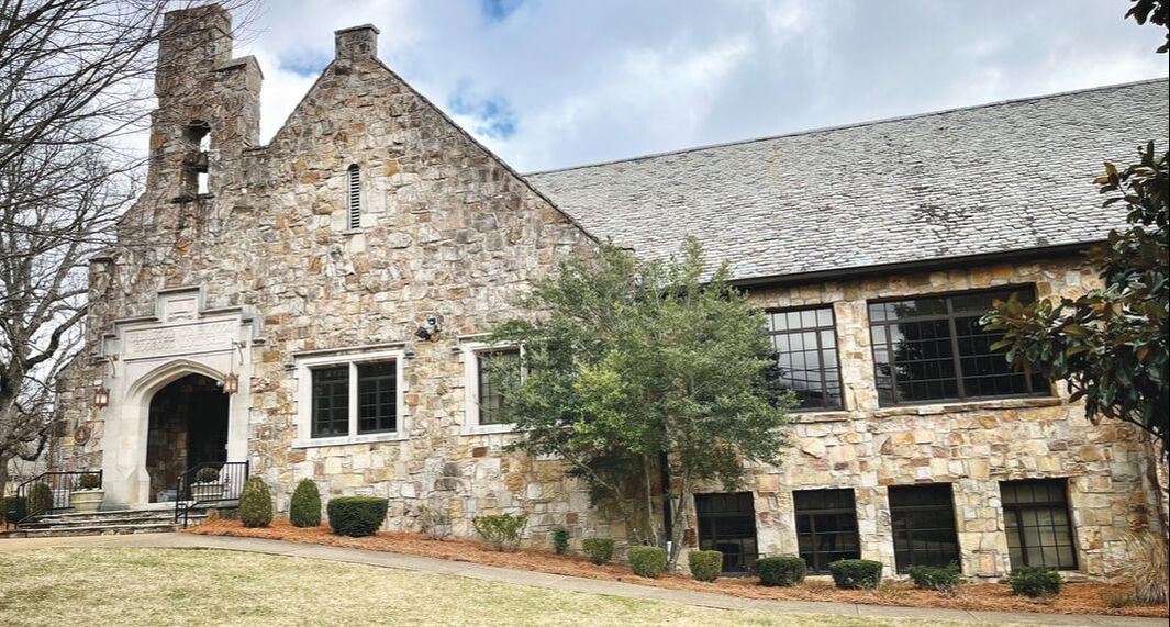
Lookout Mountain Mirror
Share your
news with us!
  • Home
  • Happenings
    • Lookout Community
    • School News
    • TN & GA Town News
    • Home & Garden
    • Local History
    • Good Reads
    • Recipe Roundup
    • Arts & Leisure
    • Travel
    • Movies with Merrile
    • Happenings at the Club
  • Advertising
  • Calendar
  • Subscriptions
  • About
  • Contact
  • Shop
  • Give & Support

Walnut St. Bridge: Pedestrian Portal to the Past

6/2/2021

2 Comments

 
Picture
Picture
Chattanooga is no stranger to bridges. In fact, the River City has six bridges spanning the Tennessee River as it meanders through town on its journey west. But, there’s only one that can be walked free of motor vehicles. The Walnut Street Bridge, often referred to as the “walking” or pedestrian bridge, not only offers a wonderful vantage point to see the best parts of Chattanooga that lend to its Scenic City moniker, but it is also an excellent avenue for exercise. However, perhaps the best thing it is good for is a trip to the past, a trip that requires looking beyond the modernization of today, right into the 19th century.

Construction on the Walnut Street Bridge commenced in 1889. The “county bridge,” as it was known at the time, opened in 1891 and was the first non-military bridge to appear in a post-Civil War Chattanooga. In order to build the bridge, the county raised money through the issuance of a $200,00 bond, which was coupled with a $25,000 contribution from newly established Hill City on the north side of the river (today’s North Shore).

To fully appreciate the story of the Walnut Street Bridge, a stroll back to Chattanooga, circa 1839, the year of its birth, is necessary. At that time, the only way to get from one side of the river to the other side was by ferry or by taking a swim. The ferry that shuttled the people of Chattanooga from the south side of the river to the north side and back again was named Ross’s Ferry because it docked at Ross’s Landing, a very popular and wildly successful trading post and the birthplace of Chattanooga. For some, getting a little wet in the Tennessee River was worth the risk. If an enslaved person successfully swam the river and made it to the north shore, he or she could hope for freedom. During those days, it was generally deemed too costly in time and money for an owner to cross the river to collect his “property.” Amazingly enough, quite a few people made it, and a tiny haphazard community was born on the north shore. After the Union gained control of Chattanooga in 1863, the tiny community’s population exploded. By the end of the Civil War, some 6,000 African-Americans were living in what had come to be known as Camp Contraband due to the Confiscation Act, which defined an escaped slave as contraband. Camp Contraband later became Hill City, the city that contributed funds for the construction of the “county bridge,” a.k.a. the Walnut Street Bridge.

Before there was a “county bridge” in Chattanooga, there was a military bridge. In order to move supplies more efficiently, one of the first things the Union Army did after gaining control of the city was to build a bridge across the Tennessee River, connecting downtown with the north shore. Under order of Montgomery Meigs, quartermaster general of the Union Army, the Meigs Military Bridge was built in 1864. It spanned the river just the tiniest bit south of where the Market Street Bridge is now. Records show the north end of the Meigs Military Bridge started roughly where Renaissance Park is today. In fact, there is an historical maker located along the trail leading to the water from the park. Construction of the massive wooden bridge came at a cost to the city’s trees, as they were all but decimated by the time the project was completed. Stone from the abandoned Bluff View furnace located on the side of the cliff on which Hunter Museum now stands was used in the construction of the bridge’s pillars.

It was a short life, however, for the Meigs Military Bridge. The bridge was only 3 years old when the temperamental Tennessee River breeched its river banks by 55 feet, whisking away the bridge and flooding the city all the way to Ninth Street. The flood of 1867 is considered to be the largest in Chattanooga history, and it would be 22 years before the city made plans to give the citizens another bridge, a bridge now known by the name Walnut Street.

Designed by Edwin Thacher, renowned engineer, the Walnut Street Bridge is a pin-connected Pennsylvania through-truss design. Constructed of wrought iron and steel, the bridge spans 2, 376 feet. Due to concern over its structural integrity and ultimately, the safety of its citizens, the city closed the bridge to vehicular traffic in 1978. Slated for demolition in the late 1980’s, a lack of funding in the city’s budget gave citizens interested in saving the bridge just enough time to start a fundraising campaign to keep the bridge alive. And, boy, did those efforts ever pay off … with a most wonderful walking bridge and linear park. At just shy of half a mile, the bridge was touted as the world’s longest pedestrian bridge when it “re-opened” for public use in 1993. Several pedestrian-specific bridges have since been constructed throughout the world, thus knocking the Walnut Street Bridge out of contention as the longest pedestrian bridge built, as it was originally designed for vehicular traffic (including horse and carriage, street cars and automobiles). Now, Gatlinburg’s Skybridge, a suspension type pedestrian bridge measuring 680 feet, claims the title as longest pedestrian bridge in the United States, and Portugal’s suspension type walking bridge at 1,696 feet claims the world title. Despite losing the title of the world’s longest pedestrian bridge, the Walnut Street Bridge still has a claim to fame: It is the oldest surviving truss bridge in the South.

For many, the outdoors has always beckoned. For others, not so much. But during the days of this persisting pandemic, lots of people have found solace in nature. In Chattanooga there are ample opportunities to get out and about, whether it be against an urban backdrop or completely immersed in nature. For an urban walking adventure, the Walnut Street Bridge is an excellent place to start. Make sure to find the “portal to the past” to fully appreciate all that Chattanooga was and how modernization has since changed the landscape.

Okay, ready for that adventure? Let’s go! Start by taking note of the buildings located at the bridge entrance closer to downtown. Before there were eye-catching condos and a boutique hotel, this site was the location of the first “framed” house in Chattanooga, known as the Latner House. Built by TJ Latner, a successful merchant in town, it boasted an incredible view as it sat perched on one of the highest points along the river in the city. Deemed one of the loveliest homes in all of the city, it was apparently coveted by Gen. Grant; shortly after arriving in Chattanooga in 1863, he promptly commandeered it as one of his many headquarters. Legend claims it was his favorite.

Shuffle on over to the right side of the bridge and find the old Bluff View furnace site … yes, there is enough of it left to appreciate where it once stood in all its boldness. Admire some of the bridge restoration donors’ nameplates and silently thank them. Stop midway across the bridge for a 360-degree view of the city and beyond to all of its elevated terrain. Mosey all the way over to the other side and, upon exiting the bridge, look up to the left at the top of the red brick building and notice the “Hill City” Lodge sign. Turn left and enter Coolidge Park, noticing the tremendous amount of trees and vegetation as you pass the pavilion, as you round toward the Market Street Bridge. Stop there and appreciate the Walnut Street Bridge: Note how it looks like several camel backs. The Pennsylvania through-truss bridge is very similar to the camel-back truss bridge. Continue under the Market Street overpass to Renaissance Park and find the Meigs Military Bridge marker. Heck, you should even take the time to find a piece of cardboard for a fun slide ride down the hill while there!

Return via Market Street to appreciate the bridge from afar. It really is magnificent. Once the stroll is complete, make sure to eat at one of many eateries in downtown or back on the North Shore. Goodness knows, this adventure undoubtedly worked up an appetite!
​
by JD Harper
JD Harper is a local author. “GLINT,”  her debut novel, is set in Chattanooga amid its rich Civil War history and rock climbing culture. Visit jd-harper.com.
2 Comments

Walking Through History: Kelly's Ferry

5/5/2021

1 Comment

 
Picture
​Lookout Valley, in the shadow of Lookout Mountain, is resplendent with historic sites beckoning local residents to search out their stories. None are more steeped in history than Kelly’s Ferry. Kelly’s Ferry and Kelly’s Ferry Road played an important role in local transportation history, have a strong connection with Cherokee history, especially during the Trail of Tears, and were the site of military events during the Battles for Chattanooga during the U. S. Civil War, 1863-1864.
​
According to the approved National Register of Historic Places application, the road and the adjacent cemetery are the oldest historic resources associated with the rural community, one of the first white settlements along the Tennessee River in Marion County. Located along the western portion of the Tennessee River Gorge, the community developed after the construction of the Federal Road, 1835. Around the same time, Col. John Kelly [1779-1845] built the ferry on a calmer section of the Tennessee River, just downstream from “the suck,” a treacherous section of the shallows and rapids first noted by Col. John Donelson during the flatboat expedition to Fort Nashborough during the winter of 1780.

Kelly, born in Greenbriar County, Va., had moved to Bledsoe County in 1808 and had served in the Tennessee General Assembly from 1817-1819, voting to approve Hamilton County’s charter in 1819. Prior to opening his ferry, he had been “instrumental in building a turnpike road to Ross’s Landing, the first bridge over the Sequatchie River and the Nashville-Chattanooga turnpike.” [Biographical Directory of the Tennessee General Assembly, 1796-1861] Kelly served as a captain during the War of 1812, leaving researchers to wonder about the “honorary designation” as colonel.

Settlers poured into the region when gold was discovered in Georgia, increasing the pressure on local governments to provide more land for the new residents and precipitating legal and political actions against the Cherokee people living in the region. Prior to the removal, Kelly’s Ferry had served as the western boundary of the Cherokee lands and served as an important link between the U. S. settlements to the west and the Cherokee settlements in the east. (Tennessee had been settled from east to west, originally across the northern half of the state in the east due to the Cherokee and Creeks settlements along the southeastern border.) When Georgia intensified its push to “remove” the Cherokee people, Chief Justice John Marshall of the U. S. Supreme Court, writing the majority opinion, ruled that the Cherokee could not be forced to relinquish control of their lands. However, President Andrew Jackson refused to enforce the ruling, instead bowing to the concept of state sovereignty.

Preparation for the removal began in March 1838 when Gen. Winfield Scott directed that the Cherokee be “moved” into temporary forts at 27 military posts in Alabama, Georgia, Tennessee and North Carolina. After several weeks in the temporary camps, the Cherokee were marched to emigration depots for the journey westward. Three detachments of about 2,660 Cherokee are known to have crossed at Kelly’s Ferry or camped at the site, accompanied by the U. S. Army guards. Colonel Kelly, still operating the Ferry, witnessed the removal.

Twenty-five years later, Kelly’s Ferry would again gain national prominence as Chattanooga became the “Gateway to the South” during the U.S. Civil War. The Tennessee River, a major access point to Chattanooga, was narrow and extremely rapid once it passed Williams Island, northwest of the city. The long and narrow gorge between Raccoon Mountain to the south and Walden’s Ridge to the north widened and slowed near Kelly’s Ferry, increasing its strategic value. Military records indicate that in January 1863, Maj. James Nocquet, the chief engineer for the Confederate Army of Tennessee, identified Kelly’s Ferry as the “most likely approach for an enemy attack” against Chattanooga.

By July 1863, Hardee’s Corps of the Army of Tennessee, CSA, arrived at Kelly’s Ferry, crossed the Tennessee on a pontoon bridge and then, after crossing, took up the bridge. Later in the autumn, Gen. Thomas C. Hindman, CSA, informed his commanding officer Gen. Braxton Bragg that the artillery and Texas cavalry posted at Kelly’s Ferry could hold the strategic location, although he did increase the forces by adding 60 Alabama infantrymen.

Union forces also identified Kelly’s Ferry as an important target, and their records note that upon mounting several scouting missions, leaders realized that the “Confederates did not maintain a constant presence at the Ferry.” Colonel John T. Wilder, in his report of September 6, 1863, wrote that “there is an absence of any Southerners at Kelly’s Ferry,” but the following day’s scouting report recorded more than 300-400 Confederate horsemen near the site.

On October 1, Union forces led by Lt. Col. James B. Cahill, commander of the 16th Illinois Infantry, easily seized the Kelly’s Ferry and secured the site while other Union troops captured first Brown’s Ferry and then all of Lookout Valley. The “Cracker Line” opened, allowing the supply of desperately needed rations to the besieged Union soldiers in Chattanooga. By the end of November, following the battles of Lookout Mountain and Missionary Ridge, Confederate forces had withdrawn and Chattanooga was secured as a Union stronghold. General U. S. Grant, headquartered in Chattanooga, would send Gen. William T. Sherman and his forces southward to divide the Deep South, hastening the end of the war.

One lovely spring afternoon, drive the sections of Kelly’s Ferry Road and consider the importance of the Tennessee River and Kelly’s Ferry in local history. Visit the Kelly’s Ferry Cemetery where many of the early settlers, including John Kelly, are buried. Walking through history can be an interesting family adventure.

by Linda Mines
Linda Moss Mines is the Chattanooga and Hamilton County Historian, Regent, Chief John Ross Chapter, NSDAR and an active member of the Chattanooga Civil War Roundtable.

1 Comment

Take a Springtime Stroll Through History

4/27/2021

0 Comments

 
Picture
Picture
April’s bright blue skies can quickly give way to the showers that will “bring May flowers,” but getting outside during this month - rain or shine -- can help you discover historical treasures while improving your fitness factors.
​
Start your month with a visit to the site of Blythe’s Ferry, easily accessible off Highway 58, at 6615 Blythe Ferry Lane near Birchwood, Tenn. In 1809, 10 years before Hamilton County’s charter, William Blythe received approval to operate a ferry at the confluence of the Hiwassee and Tennessee rivers. The ferry provided critical personal and business transportation and services for residents of Hamilton and Meigs County. During the Cherokee Removal of the late 1830s, nine of the 13 detachments organized by Chief John Ross said farewell to their ancestral lands and boarded boats bound for Oklahoma at this historic site, some groups after spending several weeks on-site waiting for the waters to rise. William Blythe chose to join his Cherokee wife and her people in their forced exile, but a ferry would be operational at the location for 185 years, until the Highway 60 bridge was built in 1994.

Pack a brown bag lunch for your visit because you’ll want time to walk the beautiful riverside site and pause for thoughtful consideration at the historical markers and monuments.

If your family stories include the possibility of Cherokee lineage, then bring those family charts and take advantage of the Native American Lineage Library and its Cherokee research tools. A Trail of Tears documentary, written for multigenerational understanding, is an excellent introduction to the Cherokee Removal for younger family members. You can also walk side-by-side with the Cherokee as you move alongside the Cherokee History Wall, tracing the story of their progress from hunter-gatherers to a literate and cultured people, allied with the settlers during the late 1790s and early 1800s, with a government reflecting the same values of their colonial neighbors.

Make time to visit the Memorial Wall, too. The names of 2,535 heads of household and the number of family members associated with each name have been duplicated from the 1835 Cherokee Census known as the Henderson Roll, recognizing those who were forced to leave. Of the 16,542 Cherokee people documented, more than 4,200 died before reaching the new Cherokee lands in Oklahoma. Most were buried along the trails or rivers, and the Memorial Wall serves as their only tombstone. Interestingly, the census notes occupations for the heads of household, farmers, weavers, spinners, businessmen, and the fact that many were literate in both English and Cherokee.

After a visit to Blythe’s Ferry, preserved primarily due to the efforts and financial support of Rita Vital and her son, Greg, you’ll want to know more about the Cherokee people and their history. Visit your Chattanooga Library where you’ll find books appropriate for all ages and then plan your next April excursion.
Less than an hour away, families can visit Nancy Ward’s gravesite and pay homage to the monumental leader, her son, Five Killer, and brother, The Raven.

Many Chattanoogans are familiar with the name of Nancy Ward, although they may not know pertinent details about her life. The Nancy Ward Chapter, NSDAR, was chartered in 1915 and chose to honor her critical role in Tennessee’s early history by adopting her name. In 1976, local artist Ben Hampton gave a Bicentennial nod to her significance by issuing a popular lithograph of Nancy Ward.

So, who was this Cherokee Beloved Woman who died in 1822 after a lifetime of leadership? Nancy Ward was born in 1738 at Chota and was a member of the Wolf clan and niece to Attakullakulla, a chief of the Cherokee nation and the father of Dragging Canoe. One of the earliest stories related her strength in battle when she fought alongside her husband against the Creeks, chewing his lead bullets to strengthen their force upon impact. After he was mortally wounded, oral tradition recounts that Nancy Ward grabbed his rife, rallied the Cherokee warriors and then led a strong charge that startled the Creeks. Victory belonged to the Cherokee, and Nancy Ward was chosen as Ghighau, Beloved Woman, by her people. As Beloved Woman, Nancy Ward spoke in tribal meetings, headed the Women’s Council and held membership in the Council of Chiefs. Her status gave her control of all prisoners and the honor of mixing the Black Drink, a sacred potion shared among warriors prior to battle.

Settlers in the lands west of the Appalachians that would become Tennessee recognized Nancy Ward’s power and sought her friendship. James Robertson’s journal includes notes regarding a visit to her home, and John Sevier, Revolutionary War hero and future Tennessee governor, credited her with two critical military successes when her warnings saved his troops from surprise Indian attacks. Lydia Bean, the first female permanent white settler west of the mountains, was taken captive by the Cherokee but saved by Nancy Ward, who became her friend as they exchanged cultural practices.

The Beloved Woman became a voice for peace on the frontier. During Cherokee-settler negotiations in 1781, Nancy Ward spoke eloquently, urging lasting peace on behalf of white and Cherokee women. Colonel William Christian noted the emotional impact of her plea, and, in an unusual action, the white delegates made no demands for Cherokee lands. Four years later, during the Treaty of Hopewell, she would speak again and offer her pipe of peace, along with her friendship, to the commissioners. As the region changed with the influx of settlers and the loss of Cherokee lands, Nancy Ward was forced to relocate from Chota southward to a site on the Ocoee River where she would operate a Federal Road inn until her death in 1822.
Visitors will find the small cemetery off Highway 411, south of Benton. Beautifully maintained by the State of Tennessee and volunteers from area NSDAR chapters, the site includes historical markers along with native flower gardens and beautiful walkways. Families with younger children may want to take a book about Nancy Ward to read aloud while sitting in the shade of the large trees.

Connecting with the past is an experience to be shared by families and friends or to be enjoyed by a solitary stroll. Either way, grab those walking shoes and plan a day to walk through history.
by Linda Mines

0 Comments

One Part Hall, One Part Sousa

11/18/2020

1 Comment

 
Picture
Strolling the sidewalks of any downtown street, on any given day, in any given town of any size has the potential to provide a history lesson. Oftentimes, lurking in plain sight is a footnote from the past that is ready to educate the observant passerby. Take the 100-block section of Ocoee Street in downtown Cleveland, Tenn., for just such an example. A keen eye will spy the historical marker attached to a column of the Craigmiles Hall building, telling the tale of a most fascinating fact of Cleveland history and how the city found its song.

As most stories go, there is usually a backstory, and this story is no exception to that rule. To fully appreciate the Craigmiles Hall building, a trip to Cleveland in the mid- to late-19th century is necessary. Pleasant (Yes, really his given birth name), aka PM Craigmiles, a banker and businessman, settled in Cleveland somewhere around 1849. During the Civil War, he made a fortune by selling gear to the Confederacy and accepting only hard currency (gold or silver), no paper money, as payment. After the war, he and his brother, John, purchased several lots in downtown Cleveland, further adding to the family’s fortune. Needless to say, the Craigmiles were a very wealthy and very influential family in Cleveland back in the day. As property development advanced and the city began to grow, PM’s son, Walter, envisioned building a space for events and shops where the community could gather. In 1877, at the ripe old age of 23, he commissioned the construction of Craigmiles Hall, Cleveland’s first opera house and “mini” mall.

Completed in 1878, Craigmiles Hall projects its Second Empire architectural style to the city by distinguishing itself from the surrounding buildings with a complex mansard roof encompassed by patterned slates, deep bracketed cornices, hooded porthole dormers, a rooftop platform and a most curious central window arrangement: two arched windows topped with a single round window above the main entrance.  No one knows who the architect of Craigmiles Hall was; however, it has been speculated that it was Peter J. Williamson, a Nashville architect known for his Second Empire style work. Williamson had been in Cleveland in the early 1870’s designing an edifice for St. Luke’s Episcopal Church, a project commissioned by John Craigmiles, Walt’s uncle, so it stands to reason that Walt would have turned to Williamson to design the “opera house.”

Craigmiles Hall’s first floor was occupied by a few shops while the theatre occupied the second floor. Measuring 85 feet by 40 feet with a 20-foot high ceiling, it was an astounding size for an opera house in a town with a population of less than 3,000 residents at the time of construction. Who knows why Walt felt compelled to build such a large space. Perhaps he had a hunch about Cleveland and its potential for growth, or maybe it was simply the folly of a 23-year-old’s ego, but regardless of the reason, he built it, and the growing population of Cleveland supported it. Craigmiles Hall soon became the cultural nexus of the city, attracting talent from near and far, not the least of which was an American composer and conductor by the name of John Phillip Sousa.

Primarily known for composing American military marches (“The Stars and Stripes Forever” and “Semper Fidelis”), Sousa visited Cleveland on January 30, 1906, where he played his song “The Diplomat” for the first time to the audience assembled at the massive Craigmiles Hall Opera House.  Honored to have such a prolific musical talent grace the city, as well as debut his newly composed song in Cleveland, city officials proudly claimed “The Diplomat” as the city song.

And that’s the story of how an opera house in Cleveland, Tenn., quite literally set the stage for the city to find its song.

“The Diplomat” has been dubbed by some musical enthusiasts as the most elegant march ever written, espousing the march as a stylish appointment of beauty and grace versus a bombast. Listening to the upbeat, light and airy march, the mind’s eye is bound to conjure up a well-dressed man or woman as he or she jauntily strides down a sidewalk in Anywhere, USA, casually tipping a hat or lending a friendly nod to the passerby.

Craigmiles Hall is located on the East side of the Courthouse Square in Cleveland at 170 Ocoee Street, NE. Currently, its first floor is home to a retail shop and the restaurant, Cobblestone Grill. The second floor theatre space has been converted into two levels offering professional office space.

It’s worth a trip to see Craigmiles Hall up close and personal in all its architectural glory. Unfortunately, with the current pandemic, the shop and Cobblestone Grill located on the first floor are closed, but hop down a block to Cafe Roma for a delicious Italian meal, and, just for a kick in the pants, stroll down a few storefronts from Cafe Roma to the Ocoee Cigar Bar for a cigar or not. Either way, stop in for a few moments to enjoy the atmosphere, it’s quite entertaining!
​
by JD Harper
JD Harper is a local author. “Glint,” her debut novel, is set in Chattanooga amid its rich Civil War history and rock climbing culture.

1 Comment

    Author

    Write something about yourself. No need to be fancy, just an overview.

    Archives

    June 2021
    May 2021
    April 2021
    November 2020

    Categories

    All

    RSS Feed

Stay up-to-date

Join our email list today for the latest news and events between issues!

Contact US

Mailing address: P.O. Box 99 Lookout Mountain, TN 37350
Physical address: 112 N. Watauga, Lookout Mountain, TN 37350
p. (423) 822-6397
Visit our sister paper: Signal Mountain Mirror

Stay Connected